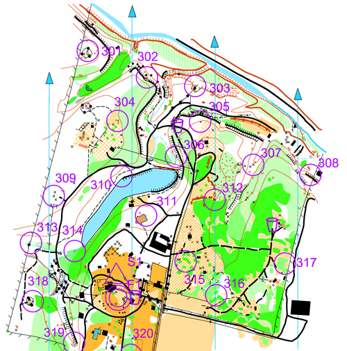
 An orienteering map is specially prepared to be used in orienteering competitions. It is a topographic map with extra details to help the competitor navigate through the competition area.
In addition to indicating the topography of the terrain with contour lines, orienteering maps also show forest density, water features, clearings, trails and roads, earthen banks and rock walls, gullies and ditches, wells and pits, fences and power lines, man-made objects, buildings, boulders, and other features of the terrain. Orienteering maps are usually on 1:15000 or 1:10000 scales. Other map scales may be provided for various purposes.
An orienteering map and a compass are the primary aids for the competitor to complete an orienteering course as quickly as possible. A map that is reliable and accurate is essential in testing the navigational skills of the competitor. The map also needs to be relevant to the needs of the competitor showing the terrain in neither too much nor too little detail.
The map is printed in five colors, which cover the main groups: Land forms, rocks and boulders, water and marsh, vegetation and man-made features:
- Brown: Land forms
Land forms are shown by contour lines. These lines are ussually at a contour interval of 5 meters. Additional symbols are provided to show earth bank, knoll, depression, small depression, pit, broken ground etc.
- Black: Rock features
This group covers cliffs, boulders, boulder fields, and boulder clusters, etc.
- Blue: Water features
This group covers lakes, ponds, rivers, water channels, marshes, and wells, etc.
- Green/Yellow: Vegetation
This group covers vegetation. White typically means open forest for great running. Green means a forest of low visibility with reduced running speed, being graded from slow running, through difficult running, to not passable. Yellow color shows open areas. Green vertical stripes are used to indicate undergrowth (slow or difficult running) but otherwise with good visibility.
- Black: Man-made features
Man-made features include roads, tracks, paths, power lines, stone walls, fences, buildings, etc.
- Magneta: Overprinting symbols
This group includes the start symbol, control points, control numbers, lines between control points, and finish. Extra symbols are available so that information relating to that event may be shown: crossing points, forbidden route, first aid post, refreshment points, etc. There are no permanent features and they cannot be included when the map is printed.
Additional specifications for technical symbols - magnetic north lines printed in blue, and register crosses showing that the printed colors are coincident - and an extra color for overprinting symbols are also available on the map. The symbols used are explained by a legend, like other maps.